
Placelab HOWTO
slides for location practical
Here you find the slides of lesson 5: Practical: Location
install Placelab
- download our fixed Placelab Package. It inlcudes a pre-filled database with all known WiFi-bacons from vienna.
- unzip the package in a folder (let's call this folder %PLACELAB%)
- add/install the ndisplab-protokoll to your WLAN:
- open the properties for the WLAN on your computer/laptop (do a right-click on the WLAN-symbol)
- select Protokoll and click the Add Button
- in the opened dialog select Install from Disk
- look for the file %PLACELAB%\native\ndisplab. This will install a new Stack into the WLAN TCP/IP stack.
- you need to start ndisplab only the very first time by hand:
- open a cmd-shell (execute cmd.exe)
- type in: net start ndisplab
- you should get a response, that ndisplab is now started.
- remember: you have to start this only the very first time! no need to start it every time you work with Placelab (that's the reason why i forgot it in this HOWTO. sorry)
- to try out Placelab: start %PLACELAB%\run\PlacelabStumblerGUI.bat. If this programm is working, than every thing is fine. Placelab is ready to use…
collect Bacons and GPS data
Placelab is not fine to collect WiFi-Bacons with GPS-data. A good solution for that task is «netstumbler». This program can collect Bacons by its ID, channel, secure/unescure datas. It also scans the GPS data from a GPS mouse.
- Install netstumbler and install a GPS/mouse (we have some fine Bluetooth-devices). Go around and collect WiFi and GPS datas.
- Make a new account for you on «http://www.wigle.net». You need an accound to upload new bacon/data.
- Wigle.net can directly import native netstumbler-data files (*.ns1).
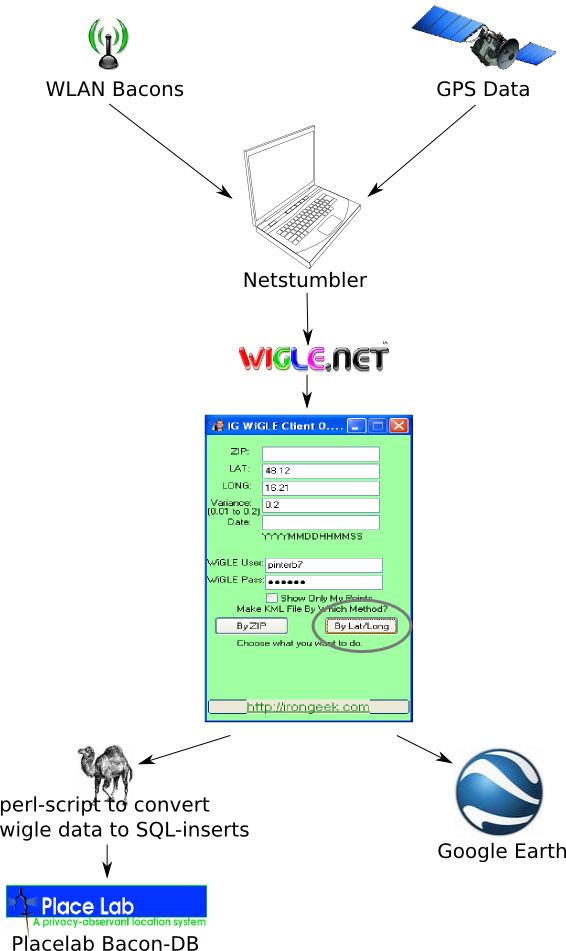
get bacon data from wigl
This is a little bit tricky. Placelab has an application to import data directly from wigle. You can either choose to import data by its logitude/latitude coords (wont work), Or by the country. For austria you can only say "give all bacons for italy, germany and austria". This works for the very first 80.000 bacons. But that's not enough! This imports only data for italy *and mayby germany)…
So we take another approuch: download the little «igigle» program.
It can import the data from wigle by the coords. For Vienna say LAT=48.12, LONG=16.21, Variance=0.2. Give your wigle account and download the bacons "By Lat/Long". The nice side effekt is, that igigle not only download the data. It also creates a kml-file for the «google-earth» application. When you import the kml-file into google-earth, than you can see all the bacons (secure/unsecure have different colors!) in the map of vienna. nice!
get bacon data into placelab
The drawback of igigle is, that the wigle-data is NOT in imported into the placelab-db. But we have the data as a plain-vanilla textfile. All we need is to convert the textfile into some kind of SQL-inserts for the placelab-db (it is a java HSQL DB). I wrote a little perl-script for that part…
- Start the perl-script. STDIN = wigl plain data, STDOUT = SQL-inserts for the placelab-db
- Start the Admin-GUI for placelab's HSQL DB. clear all previous data (truncate), load the SQL-inserts and execute them.
- Now you have all wigl-bacons in the placelab-db.
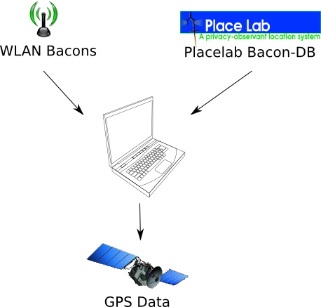
get GPS data from placelab
Placelab will calculate the current GPS data based on the WiFi bacons in your near. you have some programms in placelab that will show you your current position:
- PlacelabStumblerGUI: a GUI, that shows you all bacons in the near and the resulting position.
- ServletExample: a little Webserver, that returns the position. Start it and browse to localhost:2081/core/query/location. For your practice work this is a good starting point: simply do a HTTP-GET to this URL and you get TWO lines of the Web-Service. These are the coords of your position (or two "NaN" if the position can't calculated).
download area
We have collected some needfull things for you (mostly for windows). The downloads are password-portected. Use ubicomp/student as username/password…
fixed Placelab for Windows
You will soon remind that the downloaded version of Placelab for Windows will not work correctly. Some libraries (jar, native) will not be found by the startup-scripts (bat-files). We offer here an fixes version of Placelab, where all libraries are in the right folders. This version also includes a bat-file to start the HSQL DB GUI and pre-filled Placelab-DB for vienna.
bacon database for vienna
Mayby you try to update your Placelab-DB (the HSQL DB). And UUPPS! you kill all the data. And no backup!
No problem. Here is the complete HSQL folder with the data for vienna. simply replace the complete folder data which is located at %PLACELAB%\placelabdata and up we go…
perl script to convert wigle data
This little script generates SQL-insert statemants for the Placelab-DB. Sorry, it has no security checks, no Usage-Message, nothing thats helps you. It can only do it's work.
How to call:
bernd@turing:~/UniVie/Placelab/WigleImport$ cat 48.1216.21.txt | perl wigletxt2SQL.pl > 48.1216.21.sql
creates from the wigle-file 48.1216.21.txt (was imported by igigle) the sql-file 48.1216.21.sql
Placelab for Linux
We create 3 deb-packages for you. They should work on Debian and Ubuntu.
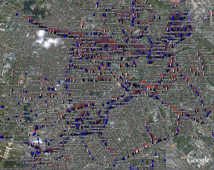
kml-file for Google-Earth
You can use this kml-file in google-earth. Open it and all WiFi-bacons will be drawn in the field of vienna. It is a good thing to check the real places of the bacons. Here you can study, where the positions are saved in the wigle-database…
You will also see, that the positions of the bacons will lie (mostly) directly on the streets and NOT in the houses.
the (missing?) pictures of this site
I think the Wiki-Software has a little problem. Sometimes (mostly every time - but not allways?!) the pictures will not rendered by the engine. I put the three pictures from above here to download. Not as sweet as inline, but it works…
Letzte Änderung: 30.04.2008, 09:52 | 1028 Worte